 Nila Kartika Wati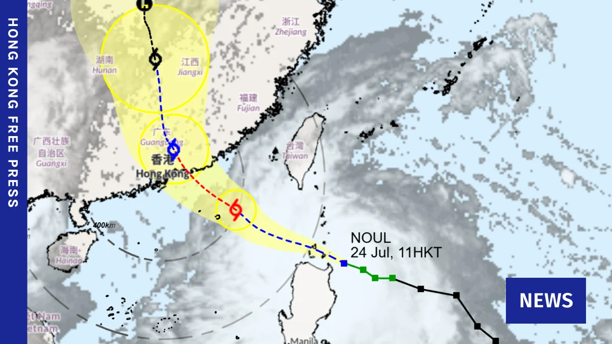
Hong Kong is on alert as Tropical Cyclone Noul churns in the region, with the Hong Kong Observatory (HKO) raising the Tropical Cyclone Signal No. 1 at 8:40 pm on Friday. The cyclone is currently moving west-northwest across the Luzon Strait and is expected to make landfall between southern China’s Huizhou and Jieyang early on Sunday. This development signals a potentially stormy weekend for the city, with forecasters anticipating heavy squally showers and thunderstorms.
Noul’s Trajectory and Hong Kong’s Preparedness
The T1 signal, the lowest of the cyclone warning signals, is issued when a tropical cyclone is located within approximately 800 kilometres of Hong Kong and poses a potential threat to the territory. As of Friday evening, Noul was moving steadily westward, bringing with it the possibility of increased wind and rain. The Observatory noted that while the precise distance of Noul from Hong Kong still carried some uncertainties, the general trend indicated a significant weather impact.

"Tropical Cyclone Noul will enter within 800 kilometres of Hong Kong around this evening," the HKO stated in its advisory. "The weather will still be very hot over Hong Kong during the day tomorrow (25 July). However, there will be swells." This suggests that while immediate gale-force winds might not be present on Saturday, the approach of the storm would lead to rougher sea conditions.
The forecast for Sunday is more definitive, with the Observatory predicting heavy squally showers and thunderstorms. This indicates a marked deterioration in weather conditions, typical of a tropical cyclone’s passage. Residents and businesses are advised to monitor official updates closely and take necessary precautions.
Understanding Tropical Cyclone Signals
The Hong Kong Observatory employs a tiered system of tropical cyclone signals to communicate the severity of an approaching storm.

- Tropical Cyclone Signal No. 1 (Standby): Issued when a tropical cyclone is centred within about 800 kilometres of Hong Kong and may affect the territory. This signal warns of the possibility of strong winds and encourages the public to prepare for potential disruptions.
- Tropical Cyclone Signal No. 3 (Strong): Issued when winds with average speeds of 41 to 62 kilometres per hour are expected to reach Hong Kong. This signal often precedes the hoisting of higher signals and indicates a more immediate threat.
- Tropical Cyclone Signal No. 8 (Gale or Storm): Issued when winds with average speeds of 63 to 117 kilometres per hour are expected to reach Hong Kong, or when such winds are already prevailing. This signal leads to significant disruptions, including the suspension of public transport, school closures, and the shutdown of many businesses. There are four variants of the No. 8 signal (Northeast, Southeast, Southwest, Northwest) indicating the direction of the strong winds.
- Tropical Cyclone Signal No. 9 (Increasing Storm): Issued when the mean wind speed is expected to increase significantly or when the wind is expected to reach storm force (average speeds of 118 to 187 kilometres per hour).
- Tropical Cyclone Signal No. 10 (Hurricane-force): Issued when winds with average speeds of 118 kilometres per hour or more are expected to reach Hong Kong. This is the highest warning signal and signifies extreme danger.
The current T1 signal indicates that while Noul is still at a considerable distance, its proximity warrants preparedness. The HKO’s detailed forecasts will be crucial in determining if higher signals will be hoisted as the storm progresses.
The Broader Context: Climate Change and Intensifying Storms
The increasing frequency and intensity of tropical cyclones, such as Noul, are increasingly being linked to the broader phenomenon of climate change. Scientists have long established a correlation between rising global temperatures and the energy available to fuel these powerful weather systems.
Oceans absorb over 90% of the excess heat trapped in the Earth’s atmosphere due to increased greenhouse gas concentrations. This warming ocean water acts as a supercharger for tropical cyclones, providing them with the thermal energy needed to intensify and become more destructive. NASA data consistently highlights the significant warming trend in ocean heat content, a critical factor in the development of severe weather events.

The strengthening of cyclones means they can bring more extreme rainfall, higher wind speeds, and consequently, greater storm surges. This has profound implications for coastal regions like Hong Kong, which are already vulnerable to rising sea levels. The potential for more powerful storms necessitates robust infrastructure, effective early warning systems, and proactive adaptation strategies.
Historical Precedents and Potential Impacts
Hong Kong has a history of experiencing severe tropical cyclones, with notable examples such as Typhoon Hato in 2017 and Typhoon Mangkhut in 2018. These events caused widespread damage, significant power outages, and considerable disruption to daily life. The approach of any tropical cyclone raises concerns about potential impacts on:
- Transportation: Suspension of MTR services, bus routes, ferry services, and the potential closure of the Hong Kong International Airport.
- Infrastructure: Damage to buildings, power lines, and communication networks.
- Public Safety: Risks associated with falling debris, strong winds, and flooding.
- Economy: Business closures, disruptions to supply chains, and potential damage to property.
The current forecast for heavy squally showers and thunderstorms on Sunday suggests that even if Noul does not reach the intensity of a Category 5 hurricane, it could still bring significant rainfall and lightning, posing risks of flash flooding and localized damage. The mention of "swells" also indicates potential hazards for coastal areas and maritime activities.

Official Statements and Public Guidance
While specific official statements beyond the HKO’s advisories are typically issued closer to the time of higher signal hoisting, the current T1 signal serves as a clear directive for the public to remain vigilant. Emergency services are likely on standby, and government departments will be coordinating preparedness measures.
During such periods, authorities typically advise the public to:
- Secure windows and doors.
- Store food and water.
- Charge electronic devices.
- Stay indoors and away from coastal areas and exposed places.
- Follow official news and advisories from the Hong Kong Observatory.
- Prepare for potential power outages.
The HKO’s commitment to providing timely and accurate weather information is paramount in mitigating the impact of such events. Their continuous monitoring of Noul’s development and trajectory will be critical in informing the public and relevant authorities.

Looking Ahead: Resilience in the Face of Increasing Storm Activity
The approach of Tropical Cyclone Noul serves as a stark reminder of Hong Kong’s vulnerability to tropical weather systems. As climate change continues to influence weather patterns, the region can expect to face more frequent and potentially more intense storms in the future.
This underscores the importance of ongoing investment in climate resilience. This includes not only strengthening physical infrastructure to withstand extreme weather but also enhancing early warning systems, improving disaster preparedness plans, and fostering public awareness and education. The proactive stance taken by the Hong Kong Observatory in issuing signals and providing forecasts is a crucial component of this resilience strategy.
The coming days will be critical in observing Noul’s evolution and its direct impact on Hong Kong. The city’s ability to navigate these challenges will depend on the coordinated efforts of its government, its residents, and the continued commitment to understanding and addressing the underlying causes of climate change. The focus remains on ensuring public safety and minimizing disruption as the weather system approaches.

 Rifan Muazin
 Muslim